A Tale of Two Sites
The following article was written by Freddie Ribeiro, Landscape Architect at BDP Delhi Studio. The article was originally published in issue No.38 of Landscape, 2013.

In October 2010, the first exploratory visit to Kamand, the site, 16 Kms from Mandi, selected for the campus of a new IIT led to one of those seminal experiences which tend to define one’s professional existence. It was clearly an opportunity that comes along but once in a lifetime. I stood in the valley, looking up at the regal snow caps in the distance, fore grounded by enormous hill sides carpeted in pine, a variety of bird sounds – their source invisible to the untrained eye-cutting through the crisp air, butterflies oblivious to my presence and a little river in a great hurry. The exhilaration was swiftly eliminated by the realization that this was a site that should ideally never be built upon. Thus began a bitter-sweet journey, similar I am sure to the predicaments faced by many a Landscape Architect before me…….
For the better part of the last three years the design Studio at BDP New Delhi has been engaged in two landmark exercises in Landscape Master planning. Running almost concurrently, the design for the campuses of IIT, Mandi and IIT, Jodhpur has been a study in contrasts – two of the most ecologically sensitive yet diverse parcels of land in the country. An empirical as well as experiential comparison of the two master plans leads to very interesting conclusions. While most design parameters are similar, the product generated by the process in each case is unique – dictated largely by what the site has to say. The similarities are rather obvious – both Technical Institutions of excellence with similar built requirement, sources of funding and sustenance, captive and floating population, assumed lifespan and pedagogy. The differences in the setting could not be starker.
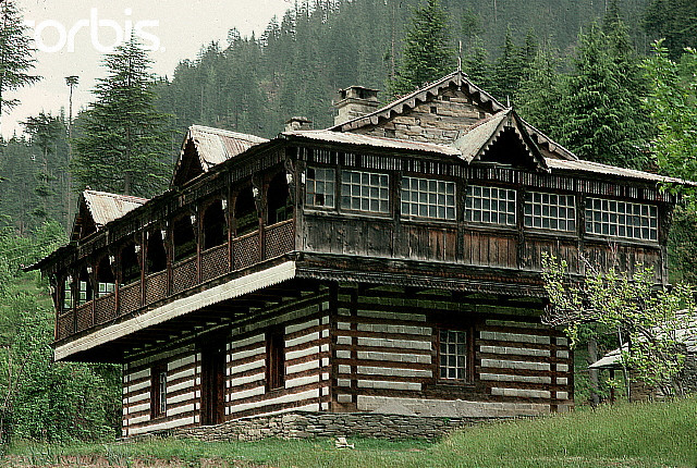
Mandi is located on a part of the extensive West Himalaya Bio-geographic Province and at 950 m above MSL, sits just below the snow line. The fragmented vegetation of the 538 acre site and its surrounding hills take the form of a heterogeneous mosaic of Chir Pine forests, broadleaved deciduous forests, scrub, cultivation and pasture lands. Just to add another fascinating layer of complexity, the snow fed River Uhl hurries through the site spawning in its wake a wide range of flora and fauna. A lot of time was spent by the team soaking in the site and learning from time tested local wisdom. A small hamlet in the Mandi-Kullu Valley with houses designed in the ‘Kathkuni’ style served as inspiration.
Creating spaces for people
‘Life, spaces and buildings, and in that order please’
Jan Gehl, Urban Designer
The primary objective was to create a human scale environment that will be a joy to experience and the approach was to break the scale of the IIT Mandi University ‘town’ down into identifiable and human scale territories. This approach is consistent with the vernacular pattern of development in hill settlements. Traditional settlements in the area are typically compact in nature and arranged along the contours. Varying topography gives pockets of lands or ‘hamlets’ for development with an organic mosaic of buildings of varying size and shapes.
These ‘Hamlets’ or developable parcels of land consist of a rich mix of activities, from living, learning, working and play; connected by a well defined pedestrian and cycling network. Our master plan vision has been centered around 5 to 10 min walking times within each zone to ensure activities are cohesively linked and that the buildings and spaces form a coherent whole. In the campus, the all important spiritual heart will be the university squares or ‘chowks’ which will form the civic focus for university life, similar to the function town centres play in traditional hill settlements.
Listening to the site
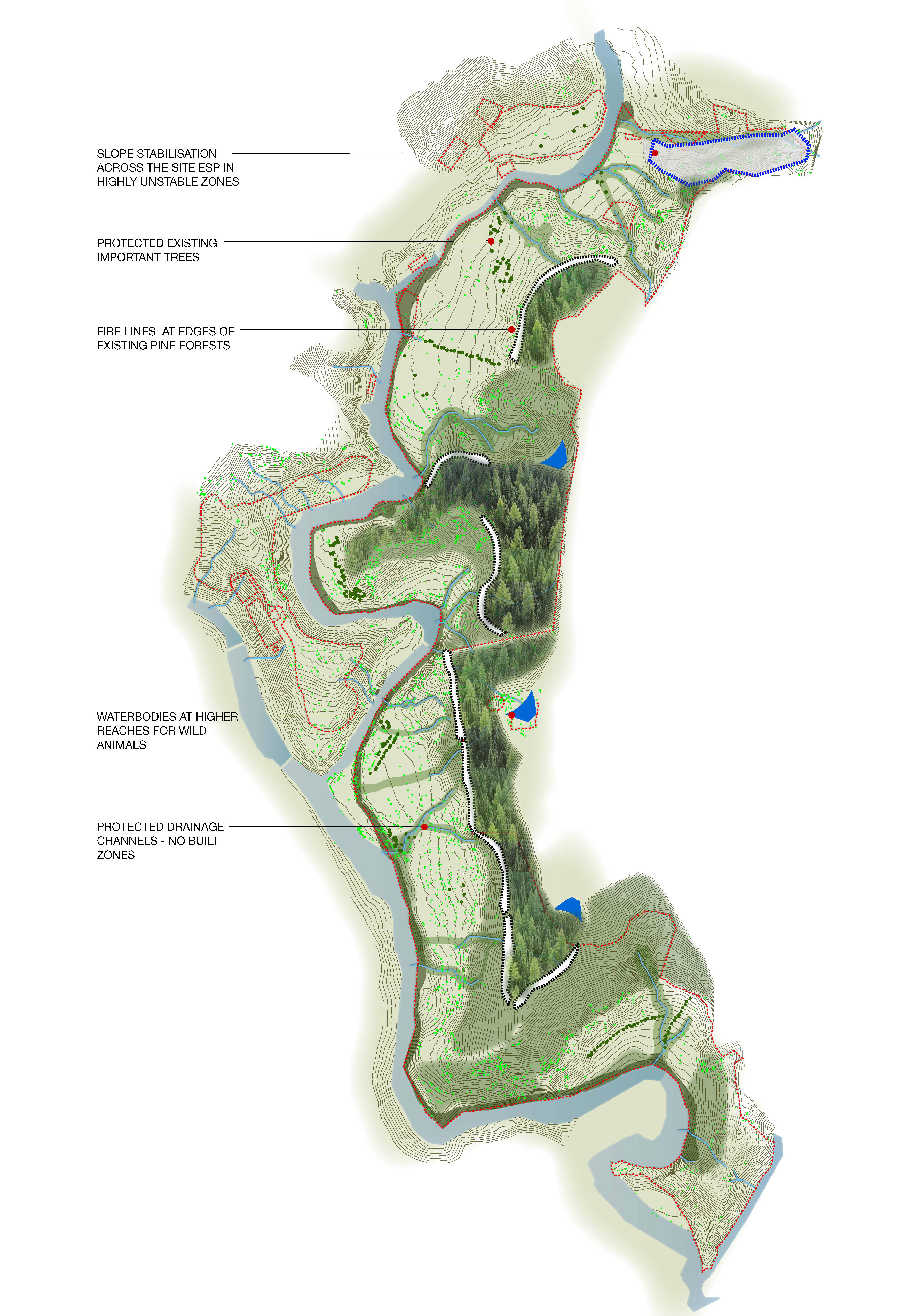
The designed landscape on a site as well endowed by nature as this has to be muted without compromising on functional requirements. To preserve the sanctity of the fragile ecology, only about 150 acres of the available 538 acres has been carefully selected for controlled intervention. The primary areas of focus are healing, protecting, enhancing and sustaining the site.
Over the years, human intervention in the form of agriculture, cattle rearing and other forms of livelihood has led to the degeneration of the natural landscape. Some of the slopes are now fragile and prone to landslides. Human carelessness has contributed to forest fires, further altering the biodiversity of the region. It will be the attempt of this proposal to repair and heal the landscape and therefore create a more diverse environment. The Landscape plan envisages the use of numerous indigenous species of plant material to strengthen and stabilize the hill slopes. Along with scrub, the dominant species on the hill sides of the upper reaches are Chir, Deodar and Silk cotton. In addition, strategically placed gabion walls or small dry retaining walls of local stone also serve to protect and maintain the gradients.
Given the necessary imposition of built environment on this land, the continuous protection of all functioning ecosystems becomes imperative. We have proposed a three pronged strategy for protecting this delicate ecosystem – Watershed management, Wild life (flora & fauna) protection and mitigation of threat from forest fires.
The water management strategies consist of maintaining the existing water run-off channels down the hill side to the river, collecting water from hill slopes through check dams, ponds and percolation tanks, harvesting roof water and implementing gravity based irrigation systems.
To preserve indigenous wild life, the plan encourages the growth of existing flora and fauna especially in the ‘riparian zones’ at the edge of the Uhl River. The introduction of exotic species of plant materials has been strongly discouraged and instead, the planting palette works with what the site (and region) has to offer.
While it is necessary to protect the existing species of wildlife on the site, some predatory species like the Leopard are dangerous to an inhabited campus, while some like the Rhesus Macaque offer nuisance value. It is found that the larger animals come down from the upper reaches to the River Uhl for a source of drinking water. The landscape proposal suggests that alternate sources of fresh water are created at the higher levels by creating collecting ponds from the natural run off to cater to some of the wild life, thereby reducing threat to life and property.
The proposed Landscape plan can play its part to help mitigate the threat of forest fires with the creation of ‘fire lines’. These are 6-10 m wide strips around the development which are cleared of all elements which can sustain a fire. This prevents the spread into the inhabited areas. Planting of certain moisture retaining species of vegetation in certain areas also helps to mitigate the fire risk.
The proposed landscape is designed to create an attractive setting for the campus with enhanced diversity.
Afforestation checks soil erosion. It also slows down the velocity of rain water which enables more efficient harvesting and collection. More importantly afforestation can be intrinsically linked to the livelihood program proposed in the campus. It is also closely intertwined with the watershed management proposal. Increase in recharge in the mountains - increases moisture in the hill slopes which increases vegetal growth which increases absorption of rainwater in the mountain which increases forest cover, leading to increase in rainfall. Some measures proposed are the cultivation of fruit orchards and agriculture as a means of livelihood for the local captive population, the establishment of Nurseries to develop and enhance the proposed planting in the campus landscape and establishment of a bio-diversity park at the upper contour level.
The site’s setting is unique and has a compelling intrinsic natural landscape which requires minimal design intervention. A conventional approach to landscape design would not work in this context as it would take away from the site’s inherent natural beauty and jeopardize its ecological balance. Our proposal focuses on a defining a ‘functional’ landscape where the major interventions revolve around connectivity and movement within the campus.
Like the terrain itself, the landscape design is proposed to be dynamic in nature with the ability to continuously evolve throughout the life of the campus keeping pace with the changing situations and building pressures. The landscape design is intended to work ‘with’ the land rather than ‘on’ the land.
The Masterplan proposed a free-flowing, loosely knit structure of open spaces around the built. The majority of the site has been retained in its existing natural setting with minor interventions that help heal and protect the natural ecology. The hierarchy of circulation encourages pedestrian and bicycle movements that connect and bind the proposed development without imposing on the land.
************
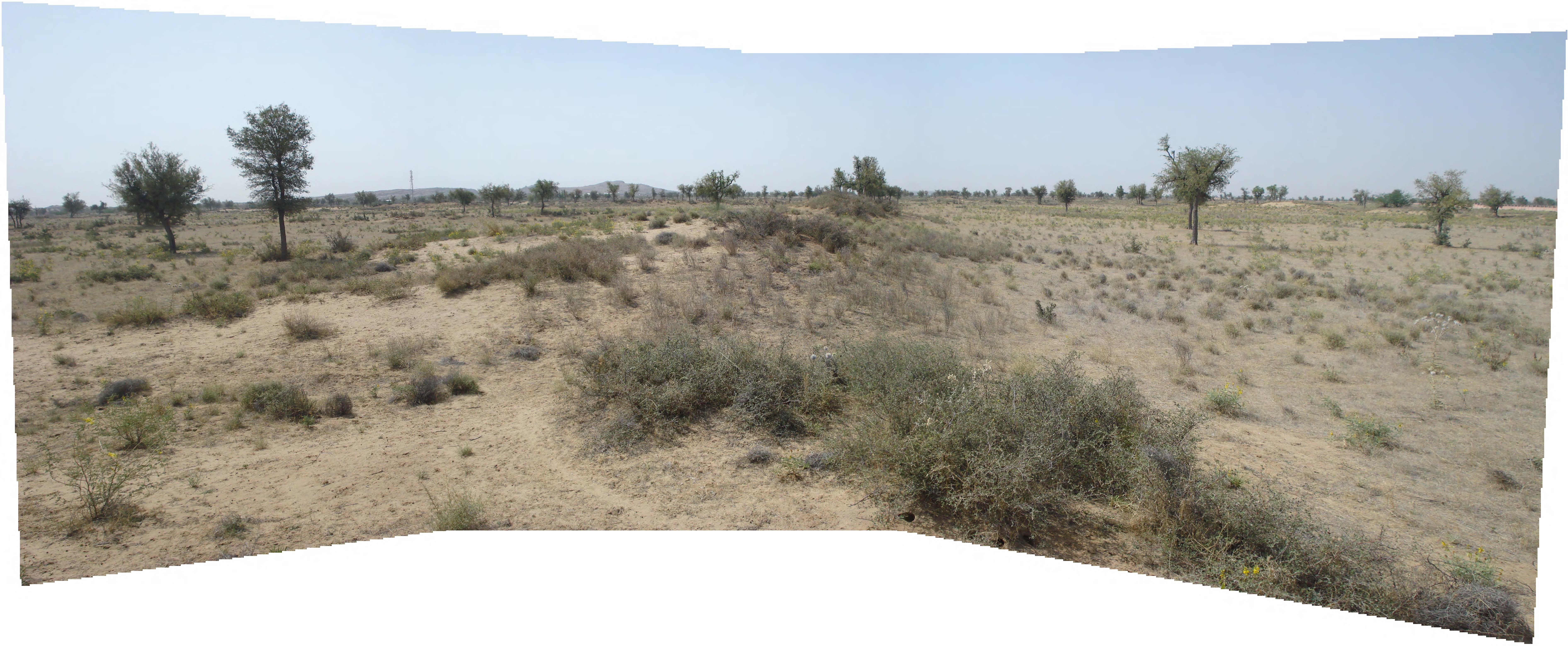
The site for IIT’s seventh campus is located to the North East of the city of Jodhpur. In terms of climate and geomorphology it could not be more different than Mandi. However, ecologically it is every bit as sensitive. The site is 842 acres of land classified as the ‘arid zone’ along the NH65 connecting Jodhpur to Nagaur. Characteristically, Jodhpur experiences extreme temperatures ranging from 49°C on a peak summer day to 1°C on a winter night. A maximum annual rainfall of 302 mm adds to the challenge. Predictably, the sandy soil and lack of moisture gives rise to vegetation which can only be described as scrub. The main species that thrive in this harsh environment are Kumat, Khejri, Babul, Bir, Jal khara, Pilu etc.
The landscape design here was a monumental challenge. A unique natural landscape called for a unique set of design solutions. To gradually convert the terrain into a sustainable and productive piece of land was recognised as the requisite area of intervention. The proposed process will involve preparing the site to accommodate and sustain a wider variety of plant species. This in turn requires that every bit of moisture available in the atmosphere and ground be captured and retained to humidify the soil and prepare it for sustaining life.
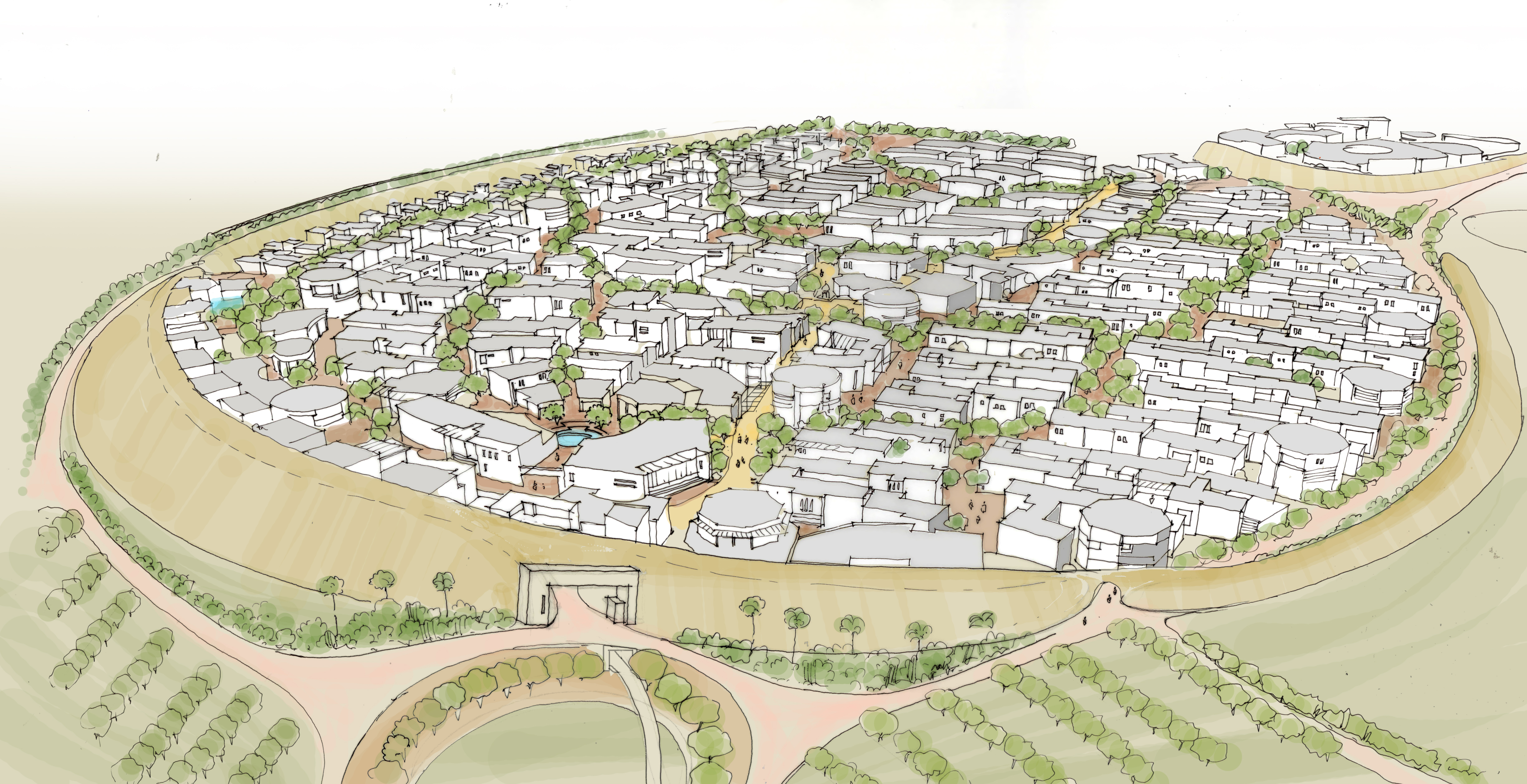
One major constraint in this process is the steady progress of desertification. In this case, the deserts creep advancing from the North West of the site at the approximate rate of 4m per decade – rapid in geological terms – needed to be checked. Integrated Design (INDÉ), a cutting edge ecological planning firm from Bangalore with vast experience in desert conditions, was enlisted to assist with the challenge. The solution devised by INDÉ was to create a series of ridges and valleys, based on the exiting watershed zones as primary generators derived as a response to forces of desertification, perpendicular to direction of creep. The featureless site is defined using micro watershed patterns to address primary health and sustainability of the land. The negative of the watershed lines are interpreted and expressed not as valleys but as connectors. Response to desertification, reinterpreted watersheds and landscape infrastructure network coalesce in evolving a comprehensive landscape structure that permeates the entire site. Thus the site evolved as a field of operations with intersecting flows of landscape infrastructure networks negotiating multiple forces – desert, wind, vegetation, water and movement.

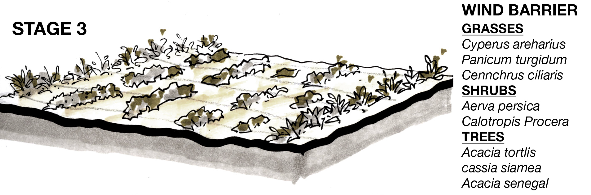

The built component is derived as a natural extension of this landscape structure, allowing the least sensitive parts of the site to be ‘sacrificed’ permanently; crests of the watershed become static as primary connectors, nodes & events, troughs remain natural, dynamic and productive.Natural division of the land as an extension of the landscape structure creates distinct precincts across the site. The precincts then can be interpreted and developed with specific uses – academic, students & faculty housing, etc. Secondary & tertiary networks of landscape further penetrate the built with open spaces thereby evolving a rational phasing strategy through the campus morphology. Predominant networks for vehicular and non-vehicular movement are distinct, but integrated and dervied through the landscape infrastructure network where feasible.
Parallel to the localisation of this landscape strategy, the need to be enlightened by hundreds of years of local wisdom led the design team to the ‘Johad’. Desert settlements have traditionally relied on the johad for protection from strong winds and also to preserve water, thus acting like a man made oasis. The need of a resilient society thriving in an unforgiving environment, working with the unique natural landscape to create their very own utopia – served as the inspiration.
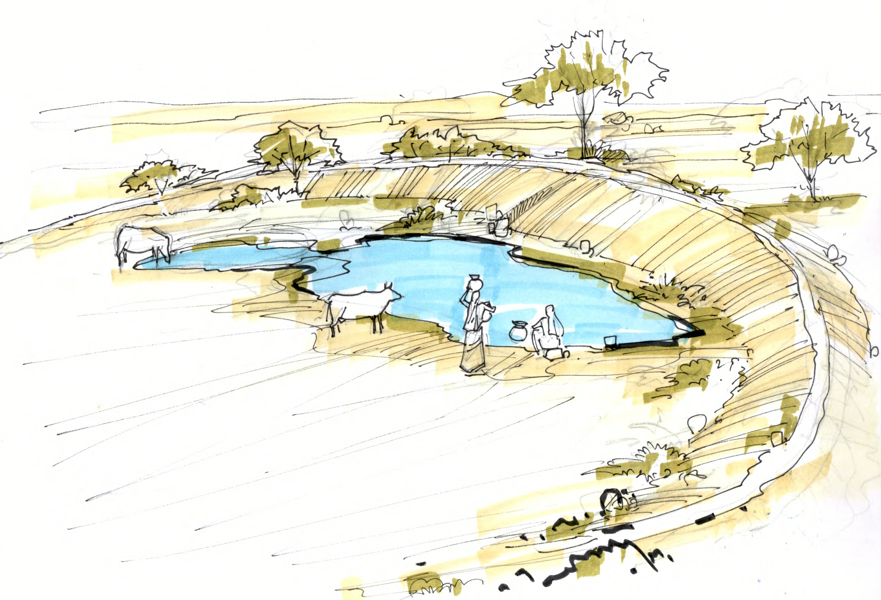
Traditional wisdom, the concept of utopia and the landscape infrastructure led to the interpretation of the Johad as the ‘signature and iconic element’ of the campus – adapted as a crescent shaped mound derived through thickening and interpretation of watershed lines appropriated rationally in scale and positioning the campus. This bund encloses the main campus, provides protection from adverse wind and shelters a central oasis in the form of a ‘baoli’ or stepped well. The built environment grid is expressed from orientation to passive solar demands overlaid over landscape infrastructure network and is morphed and interwoven with the landscape network to create a more dynamic and flexible spatial order.
The form and layout of the university at Jodhpur is thus an extension of the concept of the oasis, the true meaning of which in desert environments is ‘an isolated area of desert vegetation, typically surrounding a water source which provides a protected habitat for flora and fauna including humans’. The concept of the oasis forms the basic component of the university master plan.

A series of dry creeks and water channels emanate from the pool, which forms the heart of the core campus. It is where people meet and where the entrances to all of the faculties lie. It is a contemplative space sheltered from the potentially harsh desert environment. This allows the space to be full of activity and university life, forming the true central living and learning hub to the university. It will be inspirational and uplifting as is appropriate to the status of the university within which it is situated.
**************
Both these commissions were won through International competitions and were authored by Consortiums of appropriate professionals. In both cases, the exercises were and continue to be a huge source of learning for the vast number of professionals involved. Post occupancy data, observations and feedback will prove to be the true test. The entire team hopes to be involved then to document the learning from these rare opportunities.
IIT MANDI
The Landscape team: Freddie Ribeiro, Subhagya Atale, Harish Vangara, Mahfuj Ali, Pournima Thote.
Primary Consultant: BDP Design Engineering Pvt. Ltd.
Master Plan: BDP
Architectural Partner: UC Jain Architects
Engineering: Frischmann Prabhu
Environmental Engineering: EDS (Environmental Design Soulutions)
IIT JODHPUR
The Landscape team: Mohan Rao, Freddie Ribeiro, Subhagya Atale, Rahul Paul, Vimal Paul
Primary Consultant: Studio for Habitat Futures (SHiFt)
Master Plan: SHiFt, BDP
Environmental Engineering: EDS (Environmental Design Soulutions)
Transport Planning: iTrans
Engineering: Sterling India